
Irwin's Crossroads Historical Marker
Irwin’s Crossroads
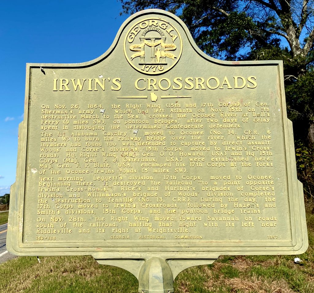
Marker Text
On Nov. 26, 1864, the Right Wing (15th and 17th Corps) of Gen. Sherman’s army [US], which had left Atlanta on Nov. 15th on its destructive March to the Sea, crossed the Oconee River at Ball’s Ferry (9 miles SW), on pontoon bridges, after two days of delay spent in dislodging the determined Confederate defenders.
The 1st Alabama Cavalry [CS] moved to Oconee (No. 14, CRR, 6 miles W) to burn the railway bridges over the river, which the invaders had found too well defended to capture by direct assault. Woods’ and Corse’s divisions, the 15th Corps, moved to Irwin’s Crossroads. Hq. Right Wing (Maj. Gen. O.O. Howard, USA) and Hq. 15th Corps (Maj. Gen. P.J. Osterhaus, USA) were established here. Maj. Gen. F.P. Blair, USA, encamped his 17th Corps at the forks of the Oconee-Irwins roads (5 miles SW).
Next morning, Leggettt’s division, 17th Corps, moved to Oconee. Beginning there, it destroyed the railroad “to a point opposite Irwin’s Cross-Roads.” Rice’s and Hurlbut’s brigades of Corse’s divisions and Williamson’s brigade of Woods’ division completed the destruction to Tennille (No. 13, CRR). During the day, the 17th Corps moved to Irwin’s Crossroads, followed by Hazen’s and Smith’s divisions, 15th Corps, and the pontoon bridge trains.
On Nov. 28th, the Right Wing moved toward Savannah on roads south of the railroad, halting that night with its left near Riddleville and its right toward Wrightsville.
Location
This marker is located on Georgia Highway 68 approximately 6.5 miles south of Tennille.
Marker Number
150-18B
Date of Origin